|
|
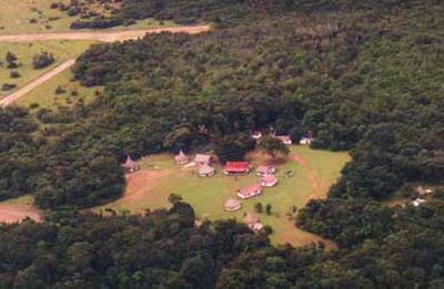
| The Yutajé Camp in the Amazonas State of Venezuela | The Yutajé area in the Amazonas State of Venezuela |
By Francisco Guánchez
The Amazonas State.
Venezuela is located in the northern edge of South America, on the Caribbean Sea. Venezuela's Amazonas State is its southernmost state, found between 0° 40' N and 6° 15' N and 63° 20' W and 67° 50' W. The Amazonas state is situated on a geological formation called the Guiana Shield. This state occupies an area of 180,145 km2, approximately the size of North Dakota. About 90% of its total area is occupied by forest and 8% by savanna vegetation. About 45% of the state's land is protected, including the Yapacana National Park, all the tepuis formations within the state limits, and the Alto Orinoco-Casiquiare Biosphere Reserve, which occupies 83,830 km2, roughly 1.5 times the size of Costa Rica (the largest Biosphere reserve of tropical rainforest in the world) (Huber, 1993). The Upper-Orinoco-Casiquiare Biosphere Reserve also encompasses the national parks: Serrania de la Neblina, Duida-Marahuaca and Parima-Tapirapeco.
The Amazonas state has an intricate fluvial network characterized by large rivers such as the Orinoco, Ventuari, Manapiare, Ocamo, Padamo, Guainia-Rio Negro, Siapa, Atabapo, Sipapo, and Casiquiare. The latter river is a branch of the Orinoco river which connects to the Amazonas river through the Rio Negro; Thus, making it possible to travel by boat from the Caribbean to the headwaters of the Amazon in Peru. This branch was perhaps the most important motivation for the visit of Alexander Von Humboldt to this area in the year 1800. In the Amazonas State there are also lowland plains which are flooded most of the year, including large lake-like bodies of water that communicate with the main course of rivers all year round or only during the high water season.
The total population of Venezuela's Amazonas state is 100,000. This is approximately 1 inhabitant per 1.6 square kilometer. 50% of the state's are Amerindians belonging to 14 ethnic groups: Yanõmami, Guahibo (Hiwi), Piaroa (Uwotuja), Yekuana (Ye'kuana, Maquiritare), Curripaco, Baré, Baniva (Baniwa), Piapoco (Tsatse), Sanema (Sanuma), Puinabe, Warekena, Hoti, Yabarana, and Panare (E'ñapa) (Signi, 1988: 45). The most numerous are Yanõmami (13,000), Guahibo (9,970), Piaroa (9,964), Curripaco (2,603), Yekuana (2,381), Piapoco (1,283), Baniva (1,192) and Baré Indians (1,136) (OCEI, 1992).
The Yutajé Area
The Yutajé Camp is located approximately at 5o 39' N, 66o 5' W, in the northern central limits of Amazonas State near Bolívar State. The Camp is in the north of the Ventuari river basin, and the area is drained by the Corocoro River, which flows into the Manapiare River, then into the Venturi River, which subsequently empties into the Orinoco River.
In the Yutajé area it is possible to access different vegetation types. According to Huber and Berry (1995), in the Yutaje area are found eleven (11) vegetation types: 1) Tall, evergreen, nonflooded forests; 2) Tall, evergreen, seasonally flooded forests; 3) Semideciduous, basimontane forests; 4) Medium, evergreen, submontane to montane forests; 5) Low, evergreen, upper montane forests; 6) Low to tall, tepui shrub, on rock; 7) Broad-leaved, shrubby upland and highland meadows on rock and peat; 8) Shrub savannas; 9) Broad-leaved, intermittently flooded, shrubby meadows on white sand; 10) Open, seasonally flooded savannas; and 11) Nonflooded, tree and shrub savannas.
Phytogeographically, the Yutajé area below the 1500 m contour is included in the Guayana Region, Central Guayana Province, and Guaniamo-Parhuasa Subdistrict (Berry et al 1995). The Central Guayana Province has a rich montane and shrubland flora with probably about 3,000-4,000 species. The dominant tree families in this province are: Chrysobalanaceae, Clusiaceae, Fabaceae, Lauraceae, Lecythidaceae, Rubiaceae, Sapotaceae, Sapindaceae and Vochysiaceae. Also in the shrublands other important families are the Clusiaceae, Combretaceae, Euphroniaceae, Humiriaceae, Melastomataceae, Ochnaceae, Rubiaceae, Rutaceae, and Theaceae.
The Venezuelan Guayana Region above the 1500 m level is considered by Huber (1995) to belong to the Pantepui Province. Therefore, the Yutajé Massif above 1800 m is included by this author in the Pantepui Province, Western Pantepui District, Yutajé Subdistrict . This Subdistrict includes Cerro Yaví, Serranía de Yutajé-Corocoro, and Cerro Guanay, located along the northern border of the Amazonas State ranging in altitude between 1800 and 2300 m. These mountains are characterized by a high diversity of high-tepui scrublands and by a relatively high level of endemism. Cerro Yutajé is perhaps a dry tepui with little or no peat formation on its summit (Berry et al. 1995). These mountains, above 800 m, are protected as National Monuments (Huber 1993).
Bibliography
BERRY, P., O. HUBER, and B. K. HOLST. 1995. Floristic Analysis and Phytogeography of the Venezuelan Guayana. in Flora of the Venezuelan Guayana. Ed. by P. Berry, B. K. Holst & K. Yatskievych. Mo. Bot. Gard. and Timber Press.
Huber, O. 1993. Notas explicativas sobre el decreto de los Tepuyes. Pantepui (Puerto Ordaz) 5:35-42.
______, and P. BERRY. 1995. Maps accompanying the Flora of the Venezuelan Guayana. Vegetation map. in Flora of the Venezuelan Guayana. Ed. by P. Berry, B. K. Holst & K. Yatskievych. Mo. Bot. Gard. and Timber Press.
OFICINA CENTRAL DE ESTADISTICA E INFORMATICA (OCEI). 1992. El Censo 90 en el Territorio Federal Amazonas. Caracas, Venezuela.
SIGNI, A. 1988. Arte y Vida. Vicariato Apostólico de Puerto Ayacucho. Editorial ex Libris, Caracas.
Links: http://mail1.lat.net/aventurismo/CA14.HTM